The coast of Queensland is dotted with islands, and we visited
a few, each one quite different and some unique. These islands were
part of mainland Australia until the end of the last Ice Age when the
sea rose some 100 feet, forming these islands and submerging what was
to become the Great Barrier Reef.
FRASER ISLAND
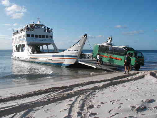
After Tin Can Bay we drove to Hervey Bay where we left our motorhome
and joined a three-day camping adventure on Fraser Island. After a rough journey
by barge/ferry, we joined Troy and 13 other people aboard a
landcruiser. There was no jetty at Fraser Island. Troy drove off the
barge’s landing platform onto the beach and then along the beach
through thick sand and a few kilometers along found a path and turned
inland. There are no roads on the island, only tracks through the sand.
We were fortunate that heavy rains had smoothed and packed the sand
otherwise it is even more bouncy and the sand gets very thick and
loose. Not too far along we saw a jeep from the same company tipped
into a ditch – the driver, who was supposed to be the one helping the
other vehicles, had taken a sandy curve badly and went over. It was
then that both Eitan and I were most thankful that we had not done the
tour independently.
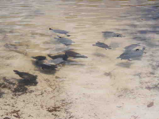
We drove eastward, crossing the island driving through expanses of
eucalypt and banksia (our “people trees”) until we arrived at Lake
Allom. Sand cannot hold water and so the existence of 20 major lakes on
the island is very special. Lake Allom is one of the perched dune
lakes, formed by vegetation collecting and settling in a sand
depression and forming a seal that holds the rainwater. About 20 small
Kreft fresh water turtles, as curious about us as we about them, came
close to the shore and stuck out their heads to look at us.
The sandy track wound its bumpy way over hills and through valleys
carpeted with forests to the eastern side of the island, to the 75-mile
beach. It is wide and pale yellow. But the sea was rough and angry with
a wide expanse of breakers and foam. Much of the foam was brown and the
water in parts looked red – the result of eucalyptus tannin seeping
into the many creeks that in turn run into the sea. Even without
warnings not to go into the sea because of 4 different kinds of
dangerous sharks, deadly jellyfish, bluebottles and stinging grass no
one would have entered.
Eli Creek is a
freshwater creek that pumps 4 million liters an hour into a fast
flowing stream. The water filters through the sand so that the tannins
are leached out resulting in wonderfully soft water. We lazily floated
down the creek, getting out before it reached the sea. It was great fun
and beautiful with lots of Pandanus trees that we’d first seen in Fiji.
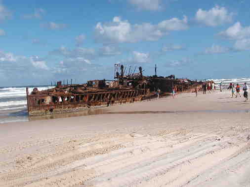
We stopped at the Maheno wreck for a photo opportunity, somewhat
miffed by the presence of other people, spoiling the picture and giving
it the feel of a tourist trap. The Maheno was built in 1904 and it
served first as a passenger ship and in WWII as a hospital ship. It was
later bought by the Japanese as a source of scrap metal.
Realizing that the propellers were the most valuable part of the ship,
they sold the propellers in Australia and while towing the boat to
Japan, the ropes snapped loose and the boat drifted to the sands. It
was a huge ship, 400 foot long, and almost all of it has been covered
by sand.
We ended our day at Cathedral Beach Resort, a
permanent tent campsite.
Eitan pointed out that it was truly a beach resort: no roads lead to
it, only a short very sandy path from the beach. There was a
covered kitchen cum eating area and close by another covered area with
the tents inside. The tents each contained 2 camp beds. Preparing for
bed in cramped quarters was laborious. Eitan got onto his bed which
tipped over, and he fell off with the bed on top of him. Amid
hysterical laughter we changed and I did better, being careful not to
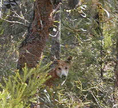
move too much. During supper we had our first sighting of a dingo
just by the camp area looking at us so sweetly! Dingoes are wild dogs
that howl like wolves. Interaction is strictly forbidden. They can be
very aggressive and have eaten children. There is a fine not only for
feeding them but also for leaving food about that they could reach. We
later saw one in the bush.
Besides the noise of the birds and later the cicadas, the quiet was
constantly broken by the zip zip as campers opened and closed their
tents against the many spiders, rats (introduced) and other curious
things. The showers and toilets were about 100 meters away. The first
night, afraid of dingoes, people armed with flashlights formed a group
before making their way to the toilets. When I went to pee at about
1.30am I woke up Eitan, who then went to the toilet and between our zip
zips we managed to wake up almost the entire camp. Almost everybody was
much younger than us – I thought they were heavier sleepers!
The following morning we drove north along the beach and through
creeks to Indian Heads. It is volcanic, and sandy Fraser Island formed
during 80,000 years around this core. We walked up to the Heads but
unfortunately the bad weather continued, and we saw only sand in the
broiling sea. In calm seas one can see sharks, manta rays turtles and
even dugongs from here.
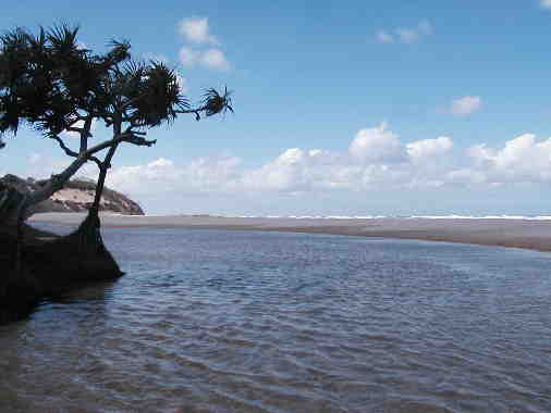
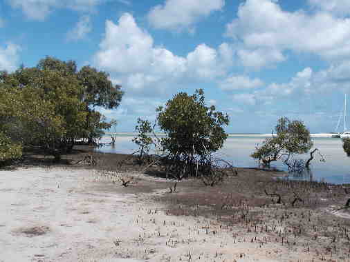
We then crossed the island to the west coast, which faces the
Australian continent. Wathumba inlet was beautiful – green sea,
mangroves and white sand. Troy pointed out that mangroves usually form
a grey mat around, but here, unusually, the sand was glittering white.
We were supposed to catch fish for our barbecued dinner. We didn’t even
get a bite and were expecting Vegemite sandwiches, a fisherman’s
fallback, for dinner so steak dinner was a surprise.
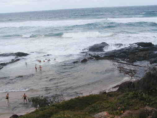
Then we made our way back and just north of Indian Head stopped at
Champagne Pools. This is the only point on the east coast where one can
safely swim. A barrier of rocks forms a large pool and when the tide is
right the waves crash over and feed the pool, leaving the dangerous
marine creatures behind. The foam was like bubbles.
It rained hard the whole night, which meant that when Eitan and I
went to the toilet, together, thankfully nobody heard our zip zip. The
following morning we drove south along the beach. The beach is not only
the beach; it is also the highway (We heard that during holidays
policemen hide behind dunes and trap drivers speeding more than 80 kph
along the sands!); and it is also a runway for the light plane that
takes people for a short aerial jaunt. Troy stopped to arrange
with the pilot to later fetch those of us who wanted a flight. To reach Lake Wabby
we had an hour’s walk through eucalypt and banksia forest and then had
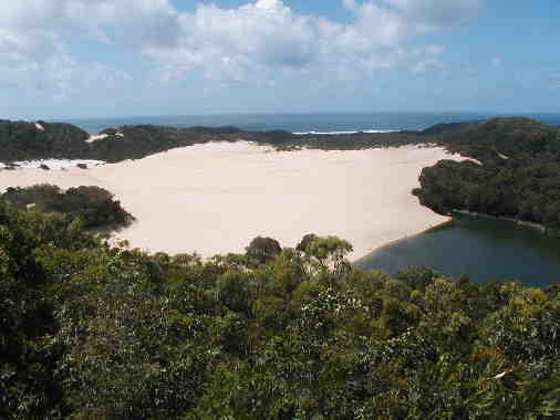
to cross a sand dune. Lake Wabby is a barrage lake, formed when sand
cuts off the exit of a creek. Although much of the 124 km-long
island is thick with vegetation there are a number of sandblows on the
beach and inland. Built up by strong southeasterly winds, these
sandblows occur when there is a break in the vegetation cover. The sand
relentlessly advances about 2 meters a year, covering everything in its
path. Lake Wabby, with its rainforest on one side and the
startling expanse of the sand dune encroaching upon bushes and trees
and gradually filling the lake itself, is a good example.
After swimming with large black catfish in the less than sweet smelling
water, we made our way back to the landcruiser. Australia is so large
that Ozzies have a different time reference to us. Troy had told us
that we had a short walk through bush to the waiting landcruiser. Forty
minutes later I wasn’t the only one to think I had taken a wrong
turning and ten minutes later we reached the vehicle.
We made our way back to the beach, where the plane landed on the
beach and whipped four off for a 20-minute flight over the island. Only
from the air could you get a true idea of the breadth of the island –
as you looked north and south all was forest covering hills and valleys
that were really covered sand dunes.
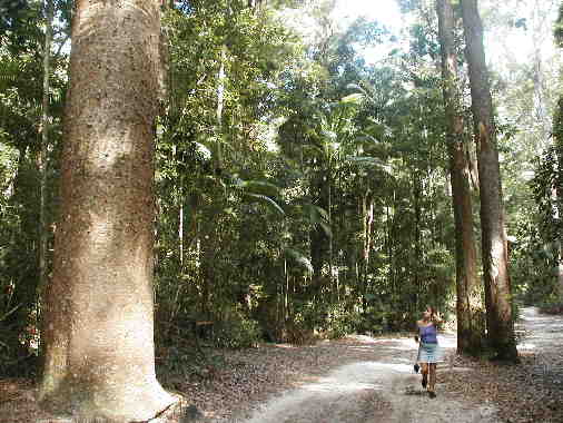
Our last stop on our
way back to the ferry point was at Yidney Scrub rainforest, the only
rainforest in the world on sand. Although logging on the island was
extensive, right up to 1991, this area was protected early on. As we
walked by the huge 200 year old kauri pine (which we had met in New
Zealand), satinay, a hardwood valued for its worm resistant properties
and used extensively on the banks of the Suez canal and in England
quays, we suddenly realized that the uniqueness of the island was that
all that we saw, although perhaps not amazing in itself, was amazing
because it all existed on sand. Sand itself doesn’t contain nutrients
and yet sustains such diverse and lush forms of life from the nutrients
in the decayed plant matter. The older forests are dying because the
nutrients that have been built up are leached by rain and are too deep
for the trees to reach them.
We eventually arrived at Moon Point to await the ferry. The weather
finally turned sunny and the sea was very calm. While we waited for the
ferry we watched little fish flying out of the water as larger fish
tried to eat them. The barge arrived and dropped its landing platform.
We watched in amusement as a jeep with a trailer got stuck in the sand
as he drove off the barge. The more he tried the deeper he got into the
sand. The barge didn’t waste time, just backed out and landed again on
the sand a few meters further up. We boarded the barge and went back to
Hervey Point, really quite sorry that this 3-day idyll was over.
 After a rough journey
by barge/ferry, we joined Troy and 13 other people aboard a
landcruiser. There was no jetty at Fraser Island. Troy drove off the
barge’s landing platform onto the beach and then along the beach
through thick sand and a few kilometers along found a path and turned
inland. There are no roads on the island, only tracks through the sand.
We were fortunate that heavy rains had smoothed and packed the sand
otherwise it is even more bouncy and the sand gets very thick and
loose. Not too far along we saw a jeep from the same company tipped
into a ditch – the driver, who was supposed to be the one helping the
other vehicles, had taken a sandy curve badly and went over. It was
then that both Eitan and I were most thankful that we had not done the
tour independently.
After a rough journey
by barge/ferry, we joined Troy and 13 other people aboard a
landcruiser. There was no jetty at Fraser Island. Troy drove off the
barge’s landing platform onto the beach and then along the beach
through thick sand and a few kilometers along found a path and turned
inland. There are no roads on the island, only tracks through the sand.
We were fortunate that heavy rains had smoothed and packed the sand
otherwise it is even more bouncy and the sand gets very thick and
loose. Not too far along we saw a jeep from the same company tipped
into a ditch – the driver, who was supposed to be the one helping the
other vehicles, had taken a sandy curve badly and went over. It was
then that both Eitan and I were most thankful that we had not done the
tour independently. 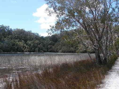
 Eli Creek is a
freshwater creek that pumps 4 million liters an hour into a fast
flowing stream. The water filters through the sand so that the tannins
are leached out resulting in wonderfully soft water. We lazily floated
down the creek, getting out before it reached the sea. It was great fun
and beautiful with lots of Pandanus trees that we’d first seen in Fiji.
Eli Creek is a
freshwater creek that pumps 4 million liters an hour into a fast
flowing stream. The water filters through the sand so that the tannins
are leached out resulting in wonderfully soft water. We lazily floated
down the creek, getting out before it reached the sea. It was great fun
and beautiful with lots of Pandanus trees that we’d first seen in Fiji.
 To reach Lake Wabby
we had an hour’s walk through eucalypt and banksia forest and then had
to cross a sand dune. Lake Wabby is a barrage lake, formed when sand
cuts off the exit of a creek. Although much of the 124 km-long
island is thick with vegetation there are a number of sandblows on the
beach and inland. Built up by strong southeasterly winds, these
sandblows occur when there is a break in the vegetation cover. The sand
relentlessly advances about 2 meters a year, covering everything in its
path. Lake Wabby, with its rainforest on one side and the
startling expanse of the sand dune encroaching upon bushes and trees
and gradually filling the lake itself, is a good example.
To reach Lake Wabby
we had an hour’s walk through eucalypt and banksia forest and then had
to cross a sand dune. Lake Wabby is a barrage lake, formed when sand
cuts off the exit of a creek. Although much of the 124 km-long
island is thick with vegetation there are a number of sandblows on the
beach and inland. Built up by strong southeasterly winds, these
sandblows occur when there is a break in the vegetation cover. The sand
relentlessly advances about 2 meters a year, covering everything in its
path. Lake Wabby, with its rainforest on one side and the
startling expanse of the sand dune encroaching upon bushes and trees
and gradually filling the lake itself, is a good example. 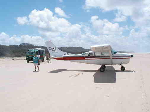
 Our last stop on our
way back to the ferry point was at Yidney Scrub rainforest, the only
rainforest in the world on sand. Although logging on the island was
extensive, right up to 1991, this area was protected early on. As we
walked by the huge 200 year old kauri pine (which we had met in New
Zealand), satinay, a hardwood valued for its worm resistant properties
and used extensively on the banks of the Suez canal and in England
quays, we suddenly realized that the uniqueness of the island was that
all that we saw, although perhaps not amazing in itself, was amazing
because it all existed on sand. Sand itself doesn’t contain nutrients
and yet sustains such diverse and lush forms of life from the nutrients
in the decayed plant matter. The older forests are dying because the
nutrients that have been built up are leached by rain and are too deep
for the trees to reach them.
Our last stop on our
way back to the ferry point was at Yidney Scrub rainforest, the only
rainforest in the world on sand. Although logging on the island was
extensive, right up to 1991, this area was protected early on. As we
walked by the huge 200 year old kauri pine (which we had met in New
Zealand), satinay, a hardwood valued for its worm resistant properties
and used extensively on the banks of the Suez canal and in England
quays, we suddenly realized that the uniqueness of the island was that
all that we saw, although perhaps not amazing in itself, was amazing
because it all existed on sand. Sand itself doesn’t contain nutrients
and yet sustains such diverse and lush forms of life from the nutrients
in the decayed plant matter. The older forests are dying because the
nutrients that have been built up are leached by rain and are too deep
for the trees to reach them.